My friend Lori and I tend to do a lot of fitness oriented things together. We’ve run marathons and half marathons together, we take long walks and frequently share workout ideas.
We’ve been wanting to hike together for awhile now. To me, hiking seems like the best of all worlds – nature, friendship and a little exercise. What’s not to love? (And you all know how much I love my everyday adventures.)
When the first opportunity arose, we jumped at it. After much internet searching we settled on an area in Potomac, Maryland declared “DCs Best Day Hike” – the Billy Goat Trails.
There are three main Billy Goat trails—A, B, and C—and they provide options for people of all walks of life and fitness levels.
Originally Lori and I had planned to hike Billy Goat B trail (“wooded nature walk, less strenuous with one scramble”) but it happened to be under repair. So we decided to throw caution to the wind and hit the Billy Goat A trail.
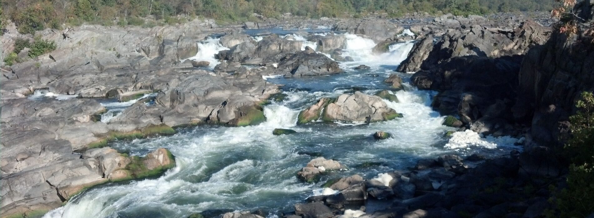
If you’re unfamiliar, Billy Goat A is shaped like a ‘C’ and works its way from the towpath to the cliffs above Mather Gorge and follows the Potomac River. The stated length of the trail is 1.75 miles but that doesn’t take into account over two miles of towpath walking to and from the actual trail. For what it is worth, our GPS clocked our excursion at five miles total.
We entered into the adventure (blissfully unaware, I might add) via the Great Falls Tavern Visitor Center.
Once parked we were told to head downstream on the C&O Canal towpath to the northern end of the Billy Goat A trail. Being good little scouts, we stopped off at the restrooms before heading to our destination. It was in that restroom where the first indication of our naïveté occurred. I noticed that the group of female hikers outside were dressed quite differently than we were. Hiking boots. Backpacks. Walking poles. Knee braces. Long pants. Wicking fabrics. You know, the opposite of our sneaker and yoga pant ensembles.
It was a clear indication of things to come.


Once we got to the entrance of the trail we were greeted with a sign that said:
Difficult Trail Ahead. Many hikers are injured every year on this section for the Billy Goat A trail. The terrain includes sharp drops, requires jumps across open areas, walking along the edges of rocks and a club up a 50’ traverse. Beyond this point, the next available exit is at the mid-point, up to one hour hike over difficult terrain. If you are tired, low on water, or unprepared for a very strenuous hike, please turn back.
Let me stop here for a minute to say that we researched this trail before deciding to tackle it. And opinions vary greatly on it. Some call it easy. Some call it challenging. There were mentions of “rock scrambles.” But no one described it in a way that prepared us for the warning sign. For example, a dude on Trip Advisor (Eastsider312 from Illinois, to be exact) posted this a week prior, “Yes, do this. We stopped to stretch our legs on a long summer road trip. I am a capable hiker but I’m not any sort of expert. I took my two girls 12 & 13 and we did the “A” part of the trail and it was fantastic. If you’re anywhere near this trail you need to do this hike.”
So if a 12 year old can do it, I figured we could do it. Sound logic, right?
Nope. About an hour into it I began to curse Eastsider312 and his fearless leg-stretching pre-teens.
Maybe this is the moment where I should admit that I have a bit of a fear of heights. Also I might as well come clean and also admit that I’m not a hiker, per se. I want to be a hiker. I mean, I deeply love the woods and nature. But I don’t regularly hike.
On with the story, then….

The trail itself is relatively easy to follow without getting lost because it is marked with blue blazes (read: blue paint splotches) that are painted on the trees or on the rocks. That being said, I did manage to steer us the wrong way relatively quickly. Because, of course. As fate would have it, however, that is the exact moment when an angel from heaven was deposited in our path.
The angel’s name was Rick. He had a red shirt on and I literally sprinted across the trail to get close enough to him so we would have someone, ANYONE to follow.
He became our sherpa.
Rick happened to be on a “training” hike and must have took pity on our clueless selves. Perhaps it was the yoga pants/t-shirt/running shoes misstep. Perhaps it was the crazed look in our eyes way too early in the experience. Whatever the reason, he hung out with us the rest of the trek chatting about his adventures, giving guidance, taking photos of us and encouraging us to take bold steps (quite literally).

Up until the point we met Rick there had been rocks, but nothing like the boulders we began to experience for the next half mile or so. Picture a landslide of boulders piled atop one another overlooking a deep river. That is a good summation I think.
I wouldn’t say it was out of breath huffing-and-puffing difficult, but it definitely was sweating profusely and try-not-to-break-an-ankle or look-down-and-immediately-panic difficult.

And then came the 50’ foot “steep cliff face” the National Park Service warned us about. Sherpa Rick gave us some advice (“look to your left, not to your right / watch your hand and foot placement / take it slow”) and lead the way.
Friends, I climbed that damn cliff.
Not only did I climb it, I wasn’t scared. Hand to God, people! I really wasn’t. Boulder-jumping, as it turns out, is way more concerning to me. (As an aside, “rock scrambling” is apparently code for boulder-jumping.)

Close to the top!
A little after the cliff climb came ‘marker 2’ which is at the only emergency exit. It is basically a cut-through back to the towpath if you don’t want to continue. (Or if you need to be carried out in a stretcher, perhaps.) It also contains another warning sign about rough terrain ahead. I guess by that point I had assumed that the tough part was over, but of course that wasn’t true. In fact, larger and more extreme rocky edge-of-a cliff type terrain awaited us. Did I mention that much of it overlooked the Potomac River? It was gorgeous and all but I was a bit distracted by the potential to drop to your death.

I was particularly fond of a lovely beach area (Purple Horse Beach) we discovered as well as crossing some sort of Indiana Jones type log bridge.
When we made it to the end of that trail, I was elated. It dumps out onto the towpath again which left us with about a mile and a half gravel walk back to the parking area. Easy-peasy. (Except for the fact that I discovered that I had a yoga pant malfunction for most of the trek. But that’s another story…)

We were super grateful to our patient and kind hiker buddy Rick. Bless his heart, this was supposed to be a cardio outing for him to prepare him for his upcoming Colorado hike. I mean, we got cardio in because we were clearly not trained for this type of excursion, but I suspect he didn’t benefit as much. He was a saint.
But you guys, WE FREAKING DID IT! We were blissfully unprepared and clueless and overwhelmed but we didn’t stop! (Checking the “do something uncomfortable” goal off my summer bucket list!)
It was a fantastic experience. It really was. It solidified my desire to continue hiking into the foreseeable future. (Rick, if you’re out there and reading this, I’m buying hiking boots and poles immediately. I swear!)
And on to the winery…

You didn’t think we went through all that and wouldn’t reward ourselves, did you? We discovered this hidden gem of a winery called Rockland Farms a mere 30 minutes away from our hike near Seneca Creek State Park.
The atmosphere was lovely, laid back and peaceful. Exactly what we needed!
Lori and I sampled two different ciders and then bought a bottle of the Honey Blossom white, at some Hot Rocket Pizza Brama and relaxed the rest of the afternoon.

It was the perfect ending to our adventure.
A few tips on tackling the trail:
- Definitely arrive early. The area gets very crowded and the hike is very popular. Beating the crowds lets you enjoy the scenery a little more.
- Set aside a good three to five hours for the hike.
- The Great Falls Tavern Visitor Center (11710 MacArthur Blvd. Potomac) has a $15 parking fee so be ready for that.
- I recommend bringing a backpack with a few essentials like water bottles, protein bars / light snacks, bug spray and bandaids.
- Ditch the sneakers. You’ll be climbing up or stepping over lots of rocks and many of them will be slippery. Save yourself a lot of anxiety and come in hiking boots. And get poles if you can!
- If you’re not up for Billy Goat A Trail, I recommend your look into B or C trail. Those are much different and even allow dogs.